


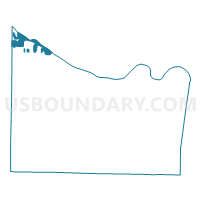
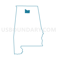
Turner Surles Community Resource Center, Morgan County, Alabama
About
Outline

Summary
| Unique Area Identifier | 522719 |
| Name | Turner Surles Community Resource Center |
| County | Morgan County |
| State | Alabama |
| Area (square miles) | 7.19 |
| Land Area (square miles) | 4.26 |
| Water Area (square miles) | 2.93 |
| % of Land Area | 59.26 |
| % of Water Area | 40.74 |
| Latitude of the Internal Point | 34.65556300 |
| Longtitude of the Internal Point | -87.07670720 |
Maps

Graphs
Select a template below for downloading or customizing gragh for Turner Surles Community Resource Center, Morgan County, Alabama


Neighbors
Neighoring Voting District (by Name) Neighboring Voting District on the Map
- Belmore Baptist Church, Limestone County, AL
- Benjamin Davis Elem School, Morgan County, AL
- Hillsboro Volunteer Fire Station, Lawrence County, AL
- Macedonia Cumberland Pres. Church, Morgan County, AL
- Morgan Co Courthouse, Morgan County, AL
- Reid Elem School-Blackburn Club House, Limestone County, AL
- Tanner Fire Dept, Limestone County, AL
- Trinity Municipal Building, Morgan County, AL
Top 10 Neighboring County Subdivision (by Population) Neighboring County Subdivision on the Map
- Athens CCD, Limestone County, AL (69,761)
- Decatur CCD, Morgan County, AL (61,269)
- Hillsboro CCD, Lawrence County, AL (1,668)
Top 10 Neighboring Place (by Population) Neighboring Place on the Map
Top 10 Neighboring Unified School District (by Population) Neighboring Unified School District on the Map
- Limestone County School District, AL (57,348)
- Decatur City School District, AL (55,683)
- Morgan County School District, AL (50,012)
- Lawrence County School District, AL (34,339)
Top 10 Neighboring State Legislative District Lower Chamber (by Population) Neighboring State Legislative District Lower Chamber on the Map
- State House District 4, AL (51,181)
- State House District 8, AL (42,351)
- State House District 7, AL (40,956)
Top 10 Neighboring State Legislative District Upper Chamber (by Population) Neighboring State Legislative District Upper Chamber on the Map
- State Senate District 2, AL (179,058)
- State Senate District 3, AL (151,168)
- State Senate District 4, AL (123,291)
Top 10 Neighboring 111th Congressional District (by Population) Neighboring 111th Congressional District on the Map
Top 10 Neighboring Census Tract (by Population) Neighboring Census Tract on the Map
- Census Tract 211, Limestone County, AL (6,578)
- Census Tract 51.01, Morgan County, AL (5,036)
- Census Tract 4, Morgan County, AL (3,929)
- Census Tract 6, Morgan County, AL (3,526)
- Census Tract 9791, Lawrence County, AL (1,668)